

c:geo

คำอธิบายของc:geo
c:geo is an open source, full-featured, always ready-to-go unofficial client for geocaching.com and offers basic support for other geocaching platforms (such as Opencaching). It does not require a web browser or exports - just install it and start right away.
Main features:
- View caches on a Live Map
- Use Google Maps or OpenStreetMaps
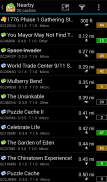
- Search for caches by various criteria
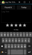
- Log your finds online or offline
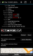
- Store cache information on your device
- Create and manage waypoints
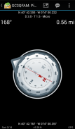
- Navigate using compass, map, or other apps
- Import/Export GPX files
- Full support for trackables
- Offline caching functions including offline maps
c:geo is a simple to use but powerful geocaching client with a lot of additional features. All you need to get started is an existing account on geocaching.com or another geocaching platform (like Opencaching).
Find caches using the live map or by using one of the many search functions.
Navigate to a cache or a waypoint of a cache with the built-in compass function, the map or hand over the coordinates to various external apps (e.g. Radar, Google Navigation, StreetView, Locus, Navigon, Sygic and many more).
Store cache information to your device directly from geocaching.com as well as via GPX file import to have it available whenever you want.
You can manage your stored caches in different lists and can sort and filter them according to your needs.
Stored caches together with offline map files or static maps can be used to find caches without an internet connection (e.g. when roaming).
Logs can be posted online or stored offline for later submission or exported via field notes.
Search and discover trackables, manage your trackable inventory and drop a Trackable while posting a cache log.
If you have problems installing or using c:geo please first have a look at our FAQ (https://faq.cgeo.org) or consult the user guide (https://manual.cgeo.org).
If there are still problems, contact support via email.
If you would like to know why c:geo needs the permissions requested, please check https://www.cgeo.org for an explanation.
c: geo เป็นโอเพนซอร์สเต็มรูปแบบพร้อมให้บริการเสมอสำหรับลูกค้า geocaching.com และให้การสนับสนุนพื้นฐานสำหรับแพลตฟอร์ม geocaching อื่น ๆ (เช่น Opencaching) ไม่ต้องใช้เว็บเบราเซอร์หรือการส่งออก - เพียงแค่ติดตั้งและเริ่มต้นทันที
คุณสมบัติหลัก:
- ดูแคชบน Live Map
- ใช้ Google Maps หรือ OpenStreetMaps
- ค้นหาแคชตามเกณฑ์ต่างๆ
- เข้าสู่ระบบค้นหาออนไลน์หรือออฟไลน์
- จัดเก็บข้อมูลแคชบนอุปกรณ์ของคุณ
- สร้างและจัดการจุดต่างๆ
- นำทางโดยใช้เข็มทิศแผนที่หรือแอพอื่น ๆ
- นำเข้า / ส่งออกไฟล์ GPX
- สนับสนุนอย่างเต็มที่สำหรับ trackables
- ฟังก์ชันแคชแบบออฟไลน์รวมถึงแผนที่แบบออฟไลน์
c: geo เป็นไคลเอ็นต์ geocaching ที่ใช้งานง่าย แต่มีคุณลักษณะเพิ่มเติมมากมาย สิ่งที่คุณต้องเริ่มต้นคือบัญชีที่มีอยู่ใน geocaching.com หรือแพลตฟอร์ม geocaching อื่น (เช่น Opencaching)
ค้นหาแคชโดยใช้แผนที่สดหรือโดยใช้หนึ่งในฟังก์ชันการค้นหาจำนวนมาก
ไปที่แคชหรือจุดเชื่อมต่อของแคชด้วยฟังก์ชันเข็มทิศในตัวแผนที่หรือมอบพิกัดไปยังแอปภายนอกต่างๆ (เช่นเรดาร์ Google Navigation StreetView Locus Navigon Sygic และอื่น ๆ อีกมากมาย)
จัดเก็บข้อมูลแคชไปยังอุปกรณ์ของคุณโดยตรงจาก geocaching.com ตลอดจนผ่านการนำเข้าไฟล์ GPX เพื่อให้สามารถใช้ได้ทุกเมื่อที่คุณต้องการ
คุณสามารถจัดการแคชที่เก็บไว้ในรายการต่างๆและสามารถจัดเรียงและกรองตามความต้องการของคุณ
แคชที่จัดเก็บไว้พร้อมกับไฟล์แผนที่แบบออฟไลน์หรือแผนที่แบบคงที่สามารถใช้ค้นหาแคชโดยไม่ต้องเชื่อมต่ออินเทอร์เน็ต (เช่นเมื่อโรมมิ่ง)
บันทึกสามารถโพสต์แบบออนไลน์หรือแบบออฟไลน์เพื่อการส่งในภายหลังหรือส่งออกผ่านบันทึกข้อมูลภาคสนาม
ค้นหาและค้นหาแทร็กที่สามารถจัดการพื้นที่โฆษณาที่สามารถติดตามได้และวาง Trackable ลงในขณะที่โพสต์บันทึกแคช
หากคุณมีปัญหาในการติดตั้งหรือใช้ c: geo โปรดดูคำถามที่พบบ่อยของเรา (https://faq.cgeo.org) หรือดูคู่มือผู้ใช้ (https://manual.cgeo.org)
หากยังมีปัญหาอยู่โปรดติดต่อฝ่ายสนับสนุนทางอีเมล
ถ้าคุณต้องการทราบว่าเหตุใด c: geo จึงต้องการสิทธิ์ที่ขอโปรดตรวจสอบ https://www.cgeo.org เพื่อดูคำอธิบาย


